Timeline
-
Consultation open
Monday 20 OctoberIn progress
-
Consultation closed
Monday 10 NovemberScheduled
-
Detailed design
TBC - 2026Scheduled
FAQ's
What do the proposed changes mean for cyclists?
The proposed upgrades will make Richmond Street safer and more comfortable for people riding bikes.
Richmond Street forms part of the Council’s strategic cycling network and the State Government’s Bikedirect route, providing an important link between the eastern suburbs and the Adelaide CBD for cyclists and other active transport users.
Currently, cycling conditions may suit more confident or experienced riders who are comfortable sharing the road with traffic. However, for many others, the existing environment may feel unsafe or stressful.
This project is designed to benefit all cyclists, but especially the large group often referred to as “interested but concerned” — people who would like to ride more but are discouraged by high traffic volumes, narrow lanes, or lack of dedicated infrastructure.
Key improvements for cyclists include:
- 3-3.6 metre wide shared-use path on the north side of Richmond Street, separated from vehicle traffic
- raised crossings and intersections to calm traffic and improve visibility at key conflict points between vehicles and cyclists
- a more connected, continuous route linking local streets to the city and beyond.
These features help create a safer and more welcoming environment for people of all ages and abilities, including families, children, older adults and newer riders.
What do the proposed changes mean for pedestrians?
The Richmond Street Safety and Streetscape Upgrade is designed to make walking in and around the area safer, more comfortable, and more accessible for everyone — including children, older adults, people with disabilities, and those using prams or mobility aids.
Key improvements for pedestrian safety and comfort include:
- Slower traffic speeds
- Raised pedestrian priority crossings and refuge islands
- 3-3.6 metre wide shared-use path on the north side of Richmond Street, separated from vehicle traffic
- Improved connections across and within the neighbourhood making it easier to move between local streets, parks, schools and shops.
What do the proposed changes mean for vehicles?
The proposed upgrades are designed to improve safety for all road users — including drivers — by creating a slower, more predictable traffic environment.
Key impacts for vehicle users include:
- Slower road environment: Narrowing the road and introducing raised crossings and intersections will naturally slow down traffic, making the street safer for everyone
- Continued two-way access: Richmond Street will remain open to two-way traffic, and all properties will retain driveway access
- Improved driver awareness: Raised platforms and pedestrian refuges increase visibility and alert drivers to the presence of people walking and riding
- Changes to parking: To accommodate safety upgrades, 25 on-street parking spaces will be removed — 17 on Richmond Street and 8 on Torrens Street.
Overall, the project aims to reduce risk without restricting access, while encouraging safer driver behaviour in a residential area with high pedestrian and cyclist activity.
What is a shared-use path and why is it proposed?
A shared-use path is a wide path designed for both pedestrians and cyclists to use together. It offers a safer, low-stress alternative to riding or walking on the road.
What are raised pedestrian crossings, and why are they being used?
Raised pedestrian crossings elevate the crossing point to the level of the footpath.
These type of crossings:
- Slow vehicles
- Make people walking or riding more visible to drivers
- Enhance accessibility for people with mobility needs or using prams.
Two raised pedestrian crossings are proposed across Richmond Street:
- A wombat crossing near Torrens Street
- A continuous footpath near Hackney Road.
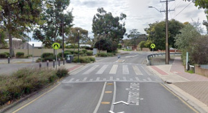
Wombat crossing:.
A wombat crossing is a type of raised pedestrian crossing marked with white stripes on the road. It gives priority to pedestrians and cyclists entering or using the crossing. Drivers must give way to anyone on or approaching the crossing.
Example of a wombat crossing: Langman Grove, Felixstow:

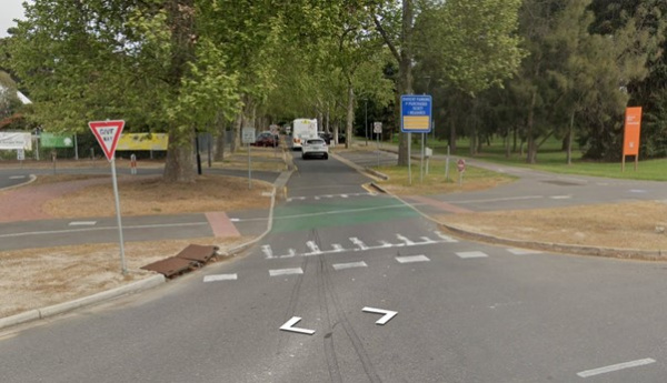
Continuous footpath: .
A continuous footpath is a pedestrian path where the paving and surface material are extended uninterrupted across the intersection with a street or driveway. This design maintains the level and visual continuity of the footpath, reinforcing pedestrian priority.
Example of a Continuous Footpath - Plane Tree Drive, Adelaide:

This treatment differs from the traditional treatment where the footpath ends at the kerb and pedestrians must step down into the roadway.
A continuous footpath ensures pedestrians remain on a consistent path, and drivers are required to give way when crossing it.
What are raised intersections and why are they being proposed?
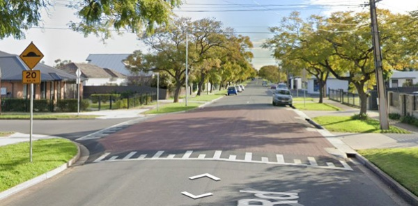
Raised intersections lift the entire road surface at junctions to slow vehicles and improve visibility. They help:
- Reduce vehicle speeds through intersections
- Make it safer for people walking and riding to cross the road.
Raised intersections are proposed at:
- Richmond Street and Hatswell Street
- Richmond Street and Regent Street
- Richmond Street and Eton Lane.
Example of a raised intersection - Ways Road, Manningham:

Will current on-street parking be affected?
Yes, some on-street parking will be removed to create a safer and more accessible environment for all road users, including pedestrians, cyclists, and drivers.
These changes are essential to make space for upgraded infrastructure that prioritises safety, visibility, and access.
Here’s a breakdown of the changes and why they’re needed:
11 parking spaces removed on Richmond Street (between Hatswell Street and Eton Lane):.
These spaces need to be removed to allow for continuous two-way vehicle access. As the road is narrowed to support slower traffic and a shared-use path, this change ensures cars can still pass safely in both directions without conflict or congestion
Five parking spaces removed on Richmond Street (between Eton Lane and Torrens Street):.
These removals are necessary to ensure clear sight lines for both pedestrians and drivers approaching the new raised pedestrian crossing (wombat crossing). This improves safety by making people crossing the road more visible to oncoming traffic and reducing the chance of collisions
Eight parking spaces removed on Torrens Street near Richmond Street:.
These spaces are being taken out to enable the construction of staged pedestrian crossings with refuge islands. This makes it much safer and easier for people to cross Torrens Street, particularly for older adults, children, and people with mobility aids who may need to cross in two steps
One parking space removed on Richmond Street (north-east corner of the Torrens Street intersection):.
This space is required to build a dedicated exit ramp for cyclists, allowing them to safely transition from the shared-use path back onto the road as they head west toward Harrow Road. This change improves route continuity and safety for bike riders.
While the total of 25 parking spaces being removed (17 on Richmond Street and 8 on Torrens Street) may impact where you can park, these changes are necessary for creating a safer, more inclusive street that supports walking, cycling and safer driving in a high-activity residential area.
Will these changes affect traffic flow or access to local properties?
Local traffic access will be maintained. The road will remain two-way, but traffic speeds will be reduced. Driveway access will not be affected.
Why is the road being narrowed?
The road is being narrowed to improve safety and create a more balanced space for all users. Narrower roads naturally encourage lower driving speeds, which helps reduce both the risk and severity of crashes.
Additionally, the space gained from narrowing the road will be reallocated to provide a wider shared-use path. This new path will offer a safer and comfortable environment for pedestrians and cyclists.
Have there been incidents on Richmond Street?
Yes. There have been six reported crashes along Richmond Street (between Hackney Road and Torrens Street) over the past five years.
Of these six crashes, 50% involved pedestrians or cyclists highlighting the need to improve safety, especially for vulnerable road users like children, seniors, walkers and cyclists.
